Skip to content
SmartCarto.com

SmartCarto.com

Unique blog presenting curious maps and gis methods

  • Home
  • Maps
  • Cartography
  • About
search
search
Imagery Downloader for Polish Orthophoto Map
Jul28July 28, 2020Cartography, GIS, Software

Imagery Downloader for Polish Orthophoto Map

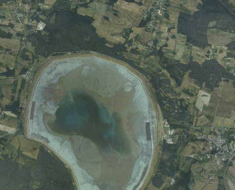
A month ago polish government shared a WMS service providing a link to GeoTIFF imagery file of the country. This is the “first stage of…

Skierbieszowski Park Krajobrazowy - 2022-09-08 - Satellite Image by ESA Sentinel 2A pic.twitter.com/Zv1XgSnB56

— Poland Sentinel (@PolandSentinel) September 13, 2022

Latest Posts

  • AI Real Estate Investment Map: Discover Mapvestor
  • Unveiling ProximityMapp: The Interactive Tool for Discovering Nearby Points of Interest
  • What AI Still Can’t Do for GIS Developers: Understanding the Technical Limitations
  • 10 Must-Use GitHub Libraries for GIS Developers
  • ChatGPT Geoparsing Based on Article Content

Subscribe to get notify about new posts!

Share on:

RSS
Facebook
fb-share-icon
Twitter
Tweet
Pinterest
fb-share-icon
LinkedIn
Share
Theme: Reblog by Moral Themes.