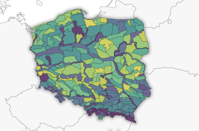
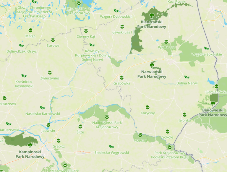
Skip to content
SmartCarto.com

SmartCarto.com

Unique blog presenting curious maps and gis methods

  • Home
  • Maps
  • Cartography
  • About
search
search
Add GeoJSON Button to Google Maps JavaScript API
Sep09December 8, 2021GIS, Maps, Software

Add GeoJSON Button to Google Maps JavaScript API

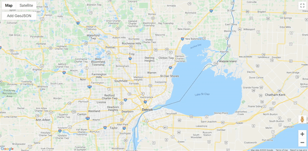
During my recent project, I built a Google Maps application using JavaScript API where Add GeoJSON Button was needed. It came out as a challenging…

Imagery Downloader for Polish Orthophoto Map
Jul28July 28, 2020Cartography, GIS, Software

Imagery Downloader for Polish Orthophoto Map

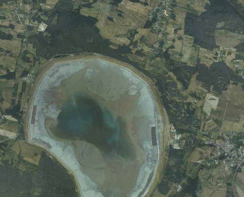
A month ago polish government shared a WMS service providing a link to GeoTIFF imagery file of the country. This is the “first stage of…

Mars and Hebrus Valles Exploration Zone
Jul19November 26, 2020Cartography, GIS, Maps

Mars and Hebrus Valles Exploration Zone

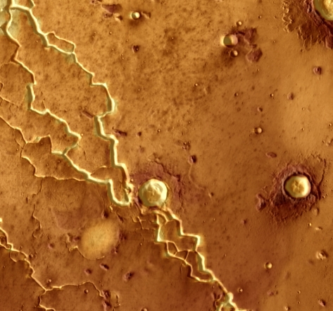
It is almost four years after the Mars Exploration Zone Map Design Competition organized by International Cartographic Association – Commission on Planetary Cartography and NASA,…

Auto Brightness Image Adjustment
Jul12July 12, 2020GIS, Software

Auto Brightness Image Adjustment

During my search for image normalization or standardization, I found an auto brightness topic to be a start of the mentioned process. The need for…

Detect Buildings in Satellite Imagery Using Machine Learning, FME vs ArcGIS Pro
May13December 15, 2022GIS, Software

Detect Buildings in Satellite Imagery Using Machine Learning, FME vs ArcGIS Pro

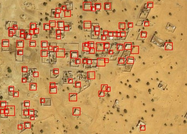
This is the first time I touched the subject of machine learning in GIS applications and I have never thought of this as a tool…

Top 30 Longest Caves on Earth
Apr12April 25, 2020Cartography, Environment, GIS, Maps

Top 30 Longest Caves on Earth

Did you see a map of the localization of the longest caves in the world? Me neither, that’s where the new idea was born to…

Protected Areas in Poland by Mapbox
Mar15March 15, 2020Cartography, Environment, GIS, Maps

Protected Areas in Poland by Mapbox

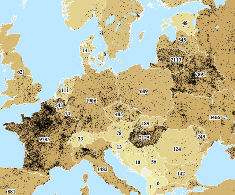
Protected planet vision and work is probably the most developed taking under the consideration the protected areas data sets. It allows to visualize the most…

Water Towers in Europe Enriched with Elevation, Addresses and Countries
Feb15April 25, 2020GIS, Maps

Water Towers in Europe Enriched with Elevation, Addresses and Countries

Open Street Map is abundant in extraordinary kind of datasets that often are hidden among main features, for example, water towers. Why water towers? Probably…

Motorways in European Countries
Jan26January 26, 2020Cartography, GIS, Maps

Motorways in European Countries

There always was an idea in my mind to obtain some data from OSM and try to use it for interesting projects. However, it turned…

The Monthly Rental Cost of 1 Bedroom Apartment in the City Centre in Poland
Jan13January 15, 2020Cartography, GIS, Maps

The Monthly Rental Cost of 1 Bedroom Apartment in the City Centre in Poland

I’ve always been excited about numbeo.com database and possibilities of this data visualisation as a map. Here I present a small project I’ve done in…

Posts navigation

Previous 1 2 3 Next

Skierbieszowski Park Krajobrazowy - 2022-09-08 - Satellite Image by ESA Sentinel 2A pic.twitter.com/Zv1XgSnB56

— Poland Sentinel (@PolandSentinel) September 13, 2022

Latest Posts

  • What AI Still Can’t Do for GIS Developers: Understanding the Technical Limitations
  • 10 Must-Use GitHub Libraries for GIS Developers
  • ChatGPT Geoparsing Based on Article Content
  • Twitter Auto Profiles: Poland Sentinel and Gdansk Bay Sentinel
  • Country Spatial Relator FME Custom Transformer

Subscribe to get notify about new posts!

Share on:

RSS
Facebook
fb-share-icon
Twitter
Tweet
Pinterest
fb-share-icon
LinkedIn
Share
Theme: Reblog by Moral Themes.